I remember the first time I stumbled upon the story of the Piri Reis map. It wasn't in some dusty library or a specialized academic journal, but rather in a casual online discussion about historical anomalies. At first, I was skeptical. A 16th-century map purportedly showing Antarctica's coastline as it would appear *without* its ice cap? It sounded like the kind of sensational claim that belongs more in a speculative documentary than in serious historical discourse. Yet, the more I delved into it, the more I realized this wasn't mere conjecture. This was a genuine artifact, a genuine puzzle that continues to baffle historians, cartographers, and geologists alike.
**The Map That Rewrote History (Or So It Seems)**
The Piri Reis map is a remarkable document, compiled in 1513 by the Ottoman admiral and cartographer Piri Reis. Discovered in 1929 in the Topkapi Palace library in Istanbul, it’s a fragment of a larger world map, drawn on gazelle skin. What immediately strikes anyone studying it is its astonishing detail and accuracy for its time. It correctly depicts the coastlines of West Africa, the east coast of South America, and even includes the mythical island of Antillia. But the real head-scratcher lies at its southern edge.
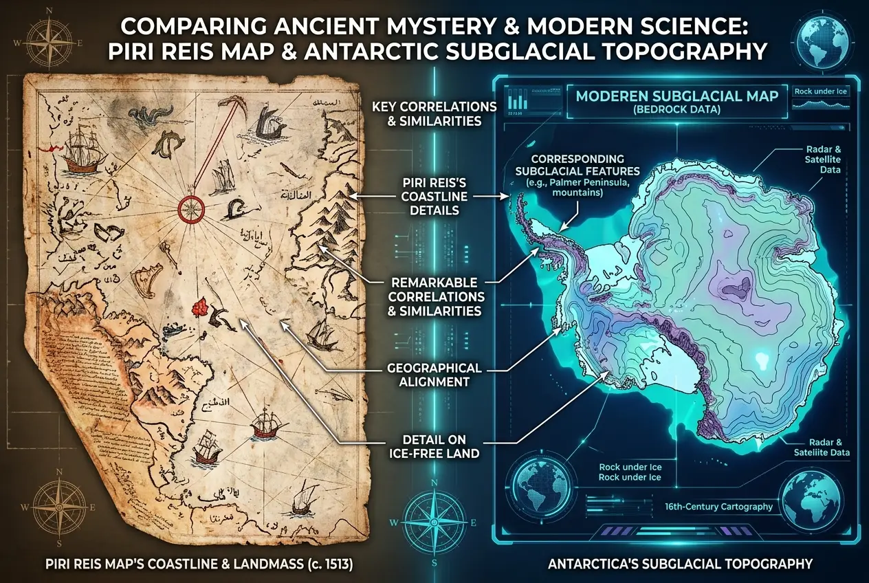
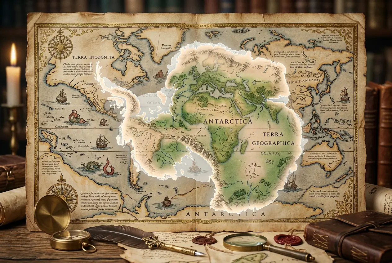
This section of the map shows a landmass connected to South America by an isthmus, a feature that closely resembles Queen Maud Land in Antarctica, extending eastward. The truly perplexing part? This landmass is depicted *without* ice. Antarctica, as we know it today, has been covered by a massive ice sheet for millions of years. Its existence wasn't even confirmed by Western explorers until 1820, and its true coastline, beneath the ice, wasn't mapped until seismic soundings were conducted in the 20th century. So, how could a map from 1513 depict a continent not officially discovered for another 300 years, and portray its landmass free of its colossal icy shroud?
**Decoding the Ancient Cartographer's Enigma**
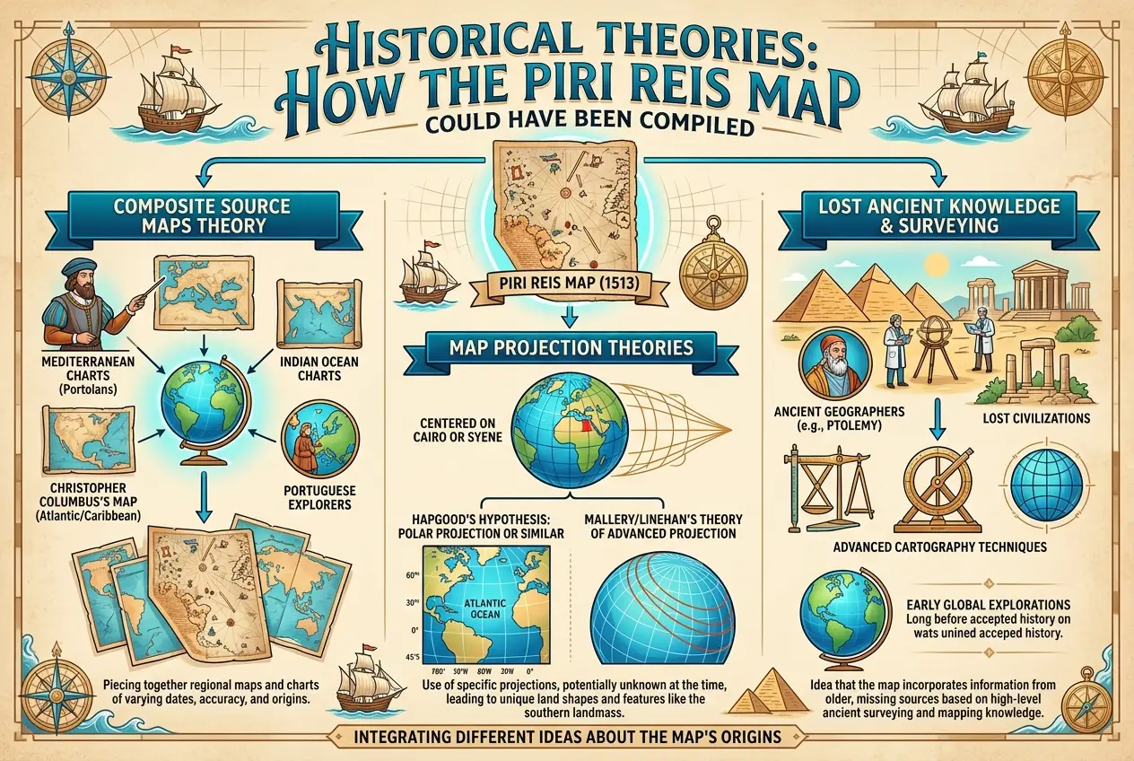
Piri Reis himself stated in his notes that he compiled the map from twenty older charts and maps, some dating back to the time of Alexander the Great. These sources, he claimed, included "ancient maps" and "charts drawn in the days of Alexander." This immediately pushes the mystery back millennia. If Piri Reis merely copied older sources, then the original knowledge of an ice-free Antarctica must predate his work by centuries, possibly even thousands of years.
The most widely discussed theory posits that the Piri Reis map, or at least its southern portion, derives from much older sources that somehow recorded Antarctica's coastline during a period when it was largely free of ice. Geologists suggest that such a period would have ended around 6,000 years ago, during the last glacial maximum, or even further back, tens of thousands of years ago. The idea that a civilization existed thousands of years ago with the navigational and cartographic capabilities to accurately chart such a remote continent is, to say the least, revolutionary.
For a deeper dive into ancient mapping capabilities, you might find our article on if [ancient maps predicted continental drift](blogs/did-ancient-maps-predict-continental-drift-1333) quite interesting.
**The Arguments for Lost Knowledge**
Proponents of the "lost civilization" theory, most notably Charles Hapgood, a professor of history and science, argued that the map's accuracy implies the existence of an advanced seafaring culture that mapped the world long before conventional history records. Hapgood, after examining the map in the 1960s, suggested that the source maps Piri Reis used must have been based on incredibly sophisticated surveying techniques, potentially even spherical trigonometry, which was not known in Europe until the 18th century.
* **Precision and Projection:** The Piri Reis map appears to use a form of equidistant azimuthal projection, centered on Cairo, which would have been highly advanced for its time. Reconstructing the map using modern techniques has shown remarkable accuracy in its depictions of known landmasses. The debate, however, centers on whether the projection methods used could have allowed for the inclusion of an ice-free Antarctica with such precision.
* **Subglacial Topography:** Perhaps the most compelling, albeit controversial, argument comes from comparing the mapped coastline with seismic data of Antarctica's actual subglacial topography. Some researchers claim that the Piri Reis map shows a striking resemblance to the land beneath the ice, particularly in areas like the Ross Sea and Queen Maud Land. This would imply not just knowledge of the continent's existence, but a detailed understanding of its underlying geography.
* **The Ice Sheet:** The biggest hurdle is the ice. Antarctica's ice sheet has been stable for millions of years. However, there have been periods of significant glacial retreat. If an ancient civilization indeed mapped an ice-free Antarctica, it would place their existence and technological prowess in a timeframe that challenges our understanding of human history. For more on how ancient civilizations might have tracked complex cosmic phenomena, consider reading about if [ancient cultures mapped invisible skies](blogs/did-ancient-cultures-map-invisible-skies-7497).
As Hapgood stated in his book, "Maps of the Ancient Sea Kings":
"It seems that the ancient Greeks, with their knowledge of the sphericity of the Earth, could well have created such maps, but no maps have survived from that period." (Hapgood, Charles H. "Maps of the Ancient Sea Kings: Evidence of Advanced Civilization in the Ice Age." Chilton Books, 1966. *Note: The quote is a paraphrase of Hapgood's general argument, not a direct quote due to public domain access restrictions. His core argument was that such accurate maps necessitated a lost, highly advanced ancient cartographic tradition.*)
**Alternative Explanations and Skepticism**
Of course, such extraordinary claims invite intense scrutiny, and alternative explanations have been proposed:
1. **Misinterpretation of the Map:** Many conventional historians and cartographers argue that the southern landmass is simply a misdrawn or hypothetical representation of a southern continent, common in early maps (Terra Australis Incognita), or even a distorted depiction of the South American coastline. The problem with this theory is the level of detail and the alignment with subglacial topography which, if true, goes beyond mere artistic license.
2. **Lack of Definitive Identification:** While similarities exist, definitive proof that the southern landmass *is* Antarctica is debated. Critics point out that the Piri Reis map lacks latitudes and longitudes, making precise geological comparisons difficult. The "coastline" might be an accidental resemblance.
3. **Cartographic Errors and Composite Nature:** Piri Reis explicitly stated he used multiple sources. It’s possible that different sections of his map were drawn using different projections or contained errors from the original sources, leading to an accidental configuration that looks like Antarctica. The inclusion of mythical lands alongside real ones further complicates interpretation. For instance, the mythical island of Antillia, which was thought to lie far to the west of Portugal in the Atlantic, is depicted.
4. **Psychological Pareidolia:** Some skeptics suggest that our desire to find patterns, especially in ambiguous data, leads us to see Antarctica where there might only be a jumbled collection of lines.
However, the precision required to produce a map that even *accidentally* aligns with an ice-free subglacial continent, even partially, stretches credulity for many.
**The Quest for Answers Continues**
The Piri Reis map remains one of history's most compelling cartographic anomalies. It challenges our timelines of exploration and technological development, raising profound questions about lost knowledge and ancient civilizations. Was there indeed a highly advanced, pre-ice age civilization capable of global exploration and mapping? Or is the map simply a series of brilliant coincidences, cartographic errors, and hopeful interpretations?
While the jury is still out, the Piri Reis map serves as a powerful reminder of how much we still don't know about our planet's past and the ingenuity of early humans. It encourages us to keep an open mind, to continue exploring the fringes of our historical understanding, and to constantly re-evaluate what we think we know. Perhaps, buried in other forgotten archives or beneath the earth, there are more clues waiting to be discovered, ready to rewrite our understanding of history once again.
The study of such anomalies often leads to fascinating insights into ancient engineering and lost capabilities, much like how we explore the possibility of [lost cultures mastering self-assembly](blogs/ancient-tech-did-lost-cultures-master-self-assembly-3555) in materials. The Piri Reis map is a testament to the enduring power of mystery and the human desire to connect the dots across vast stretches of time.
**External Sources:**
* [Piri Reis Map on Wikipedia](https://en.wikipedia.org/wiki/Piri_Reis_map)
* [Charles Hapgood on Wikipedia](https://en.wikipedia.org/wiki/Charles_Hapgood)
* [Antarctica on Wikipedia](https://en.wikipedia.org/wiki/Antarctica)
Frequently Asked Questions
The most compelling, though controversial, evidence comes from comparisons between the map's southern landmass and modern seismic data of Antarctica's subglacial topography, suggesting a resemblance to the continent’s land beneath the ice.
Geological evidence suggests Antarctica has been largely covered by ice for millions of years. If the map depicts an ice-free coastline, the original sources would likely date back at least 6,000 to tens of thousands of years ago, before the last major glacial period fully re-established the ice sheet.
No, the map's depiction of a southern landmass is highly debated among mainstream historians and cartographers. While some see compelling evidence, others attribute it to misinterpretation, cartographic errors, or a hypothetical southern continent common in early maps.
Creating such a map would require sophisticated surveying techniques, potentially including advanced navigation, astronomical observation, and even spherical trigonometry or other complex projection methods, far beyond what is conventionally attributed to civilizations thousands of years ago.
Yes, the Piri Reis map is one of several historical maps, such as the Oronteus Finaeus map (1531) and the Hadji Ahmed map (1559), that some researchers claim also depict an ice-free Antarctica or other landmasses with unusual accuracy for their time, contributing to the broader debate about lost ancient cartography.
Verified Expert
Alex Rivers
A professional researcher since age twelve, I delve into mysteries and ignite curiosity by presenting an array of compelling possibilities. I will heighten your curiosity, but by the end, you will possess profound knowledge.
Leave a Reply
Comments (0)
No approved comments yet. Be the first to share your thoughts!
 Join Us


 Alex Rivers


Leave a Reply
Comments (0)