I recently stumbled upon a fascinating riddle that challenges everything I thought I knew about ancient knowledge. Imagine holding an old, yellowed map, intricately drawn, depicting coastlines and landmasses. Now, imagine that same map, centuries old, showing features of our planet that science only truly understood in the 20th century. Sounds like science fiction, right? Yet, this isn't fiction. This is the curious case of ancient cartography and the astonishing suggestion that some forgotten civilizations might have glimpsed Earth's geological past, perhaps even predicting its slow, inexorable dance: continental drift.
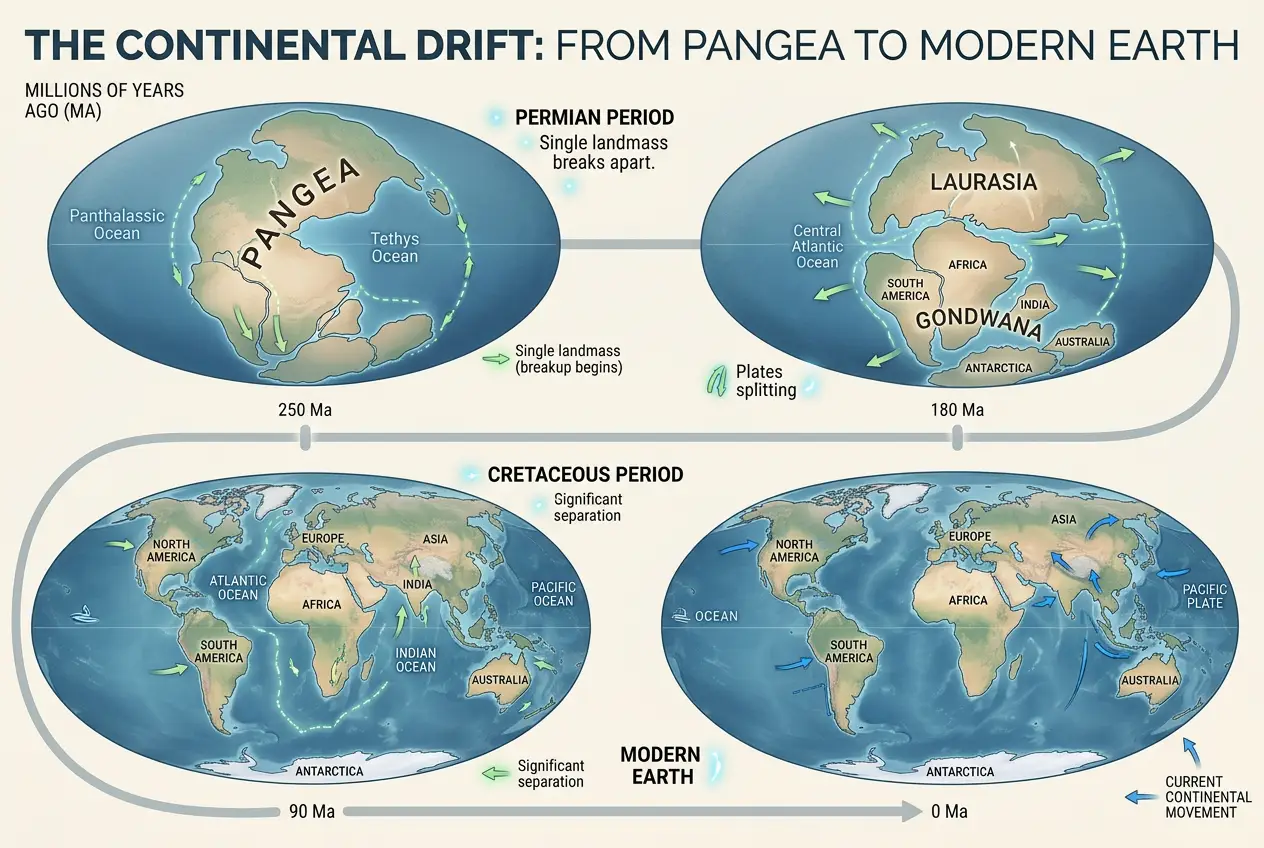
For most of human history, the idea that continents move across the face of the Earth seemed utterly outlandish. It was only in the early 20th century, with the groundbreaking work of Alfred Wegener and the later development of plate tectonics theory, that we began to grasp the dynamic nature of our planet. The concept of Pangea, a supercontinent that existed hundreds of millions of years ago before breaking apart, is now a cornerstone of geology. But what if echoes of this deep past were preserved, not in rocks, but in ancient scrolls and parchments?
**The Unsettling Accuracy of Old Maps**
The art and science of mapmaking, known as cartography, has a history as old as civilization itself. From rudimentary cave drawings to the sophisticated navigational charts of the Age of Discovery, maps have always been humankind's attempt to define and understand their world. You can explore the rich history of this craft on [Wikipedia's History of Cartography](https://en.wikipedia.org/wiki/History_of_cartography). Early maps, while often beautiful, were frequently inaccurate by modern standards, reflecting the limited tools and geographical knowledge of their creators. Yet, some ancient maps present an uncanny level of detail and peculiar features that seem to defy the known technological capabilities of their time.
I’ve always been drawn to anomalies, those little glitches in the matrix of history that whisper of something more. And these maps are a prime example. They're not just slightly off; some are so remarkably *different* from contemporary maps, yet so strangely *accurate* in depicting landmasses as they would have appeared in vastly different geological epochs, that they force us to ask: how?
**Pangea's Ghost in the Cartography Machine?**
The theory of plate tectonics explains how Earth's lithosphere is broken into large plates that are in constant motion. This movement causes continents to drift, collide, and separate over geological timescales, shaping mountains, oceans, and even climates. The most famous outcome of this process is the supercontinent Pangea, which began breaking apart around 175 million years ago. Our modern continents are merely fragments of this colossal landmass, still on their slow journey across the globe. You can read more about the incredible journey of continents on [Wikipedia's Plate Tectonics page](https://en.wikipedia.org/wiki/Plate_tectonics).
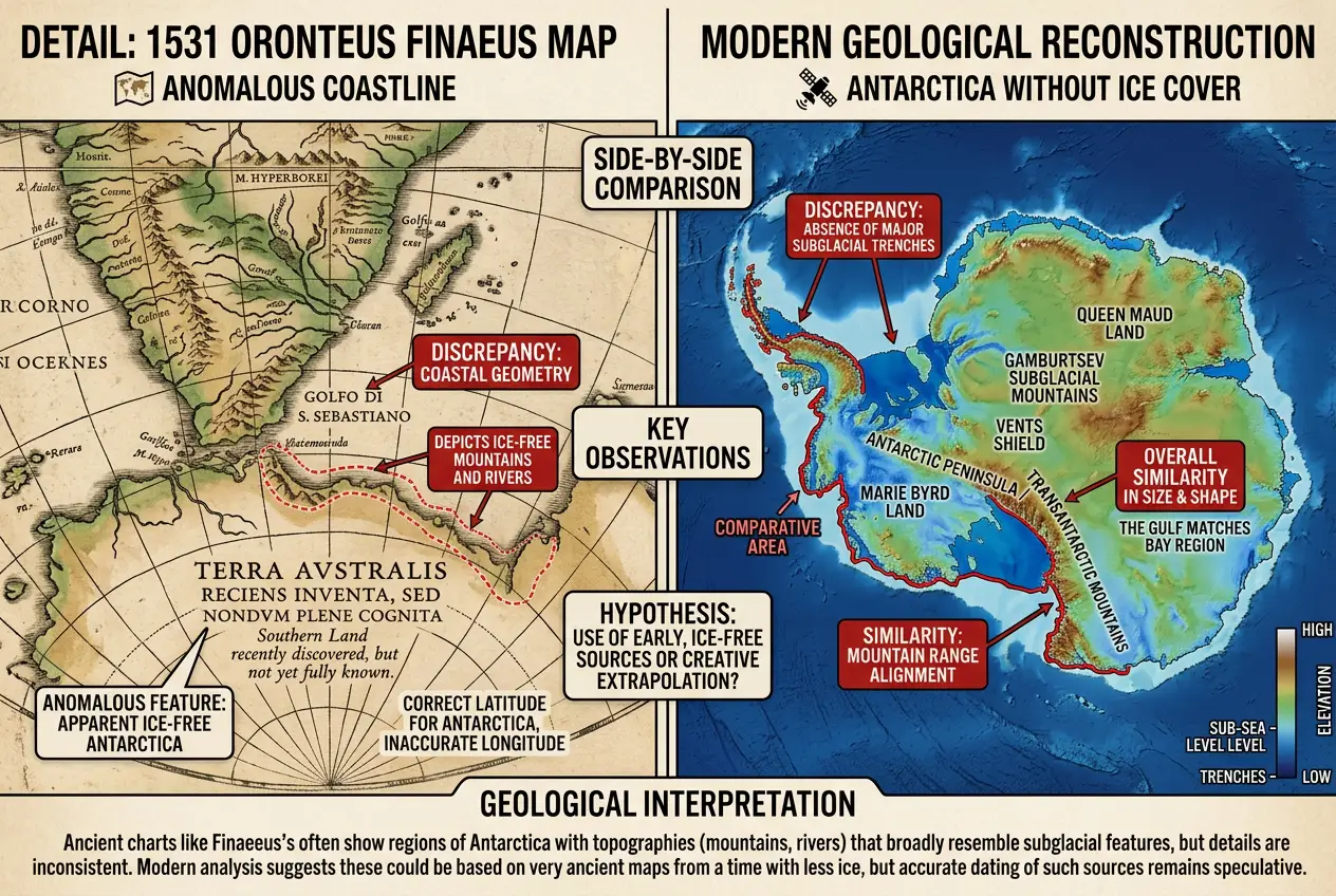
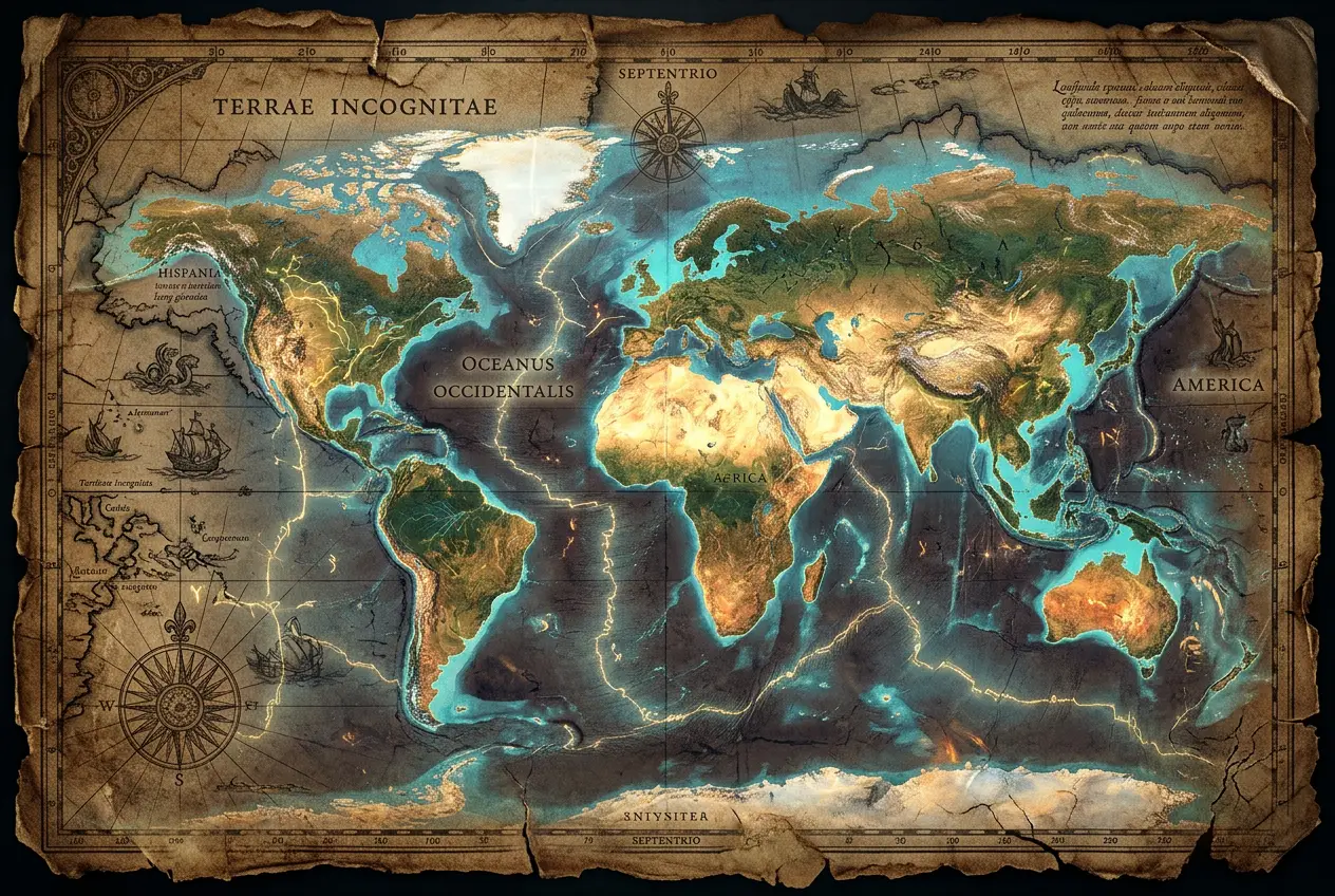
Now, consider some ancient maps. While most were based on direct observation and exploration, a few stand out. One of the most compelling examples is the **Oronteus Finaeus map** of 1531. This map depicts Antarctica, not as an ice-covered wasteland, but with rivers, mountains, and ice-free coastlines, remarkably similar to what geologists believe Antarctica looked like millions of years ago, before it was completely covered by its massive ice sheet.
"The map of Oronteus Finaeus is perhaps the most astounding of all the ancient maps, for it shows Antarctica not only free of ice but also with what appear to be the actual shorelines and topography of the continent below the ice." – Charles Hapgood, *Maps of the Ancient Sea Kings*
This wasn't an isolated incident. Other maps, like segments of the **Piri Reis Map** (which I covered in a previous blog: [Piri Reis Map: Secrets of an Antarctic Coastline](blogs/piri-reis-map-secrets-of-an-antarctic-coastline-7148)), also hint at a knowledge of landmasses in a state that contradicts the conventional understanding of the age. How could 16th-century cartographers, or the ancient sources they allegedly drew from, possess knowledge of a continent under millions of tons of ice, or even worse, a continent as it existed in a prior geological epoch?
**The Enigma of Pre-Scientific Knowledge**
Several theories attempt to explain these anomalies:
1. **Sheer Coincidence or Artistic License:** Skeptics argue that the similarities are either coincidental or the result of cartographers simply filling in unknown areas with imaginative landforms. This explanation, however, struggles to account for the consistent recurrence of seemingly "geologically correct" details across multiple maps.
2. **Advanced Ancient Civilizations:** This is where the curiosity truly sparks! Could a highly advanced, pre-cataclysmic civilization have existed, possessing the means to accurately map the Earth? This civilization might have had knowledge of Earth's geology, perhaps even understanding plate tectonics, and their maps were then passed down through generations, albeit imperfectly, until they reached later cartographers. Think about the precision seen in structures like Gobekli Tepe ([Gobekli Tepe: First Observatory or Cosmic Calculator?](blogs/gobekli-tepe-first-observatory-or-cosmic-calculator-6119)) – it hints at sophisticated ancient understanding.
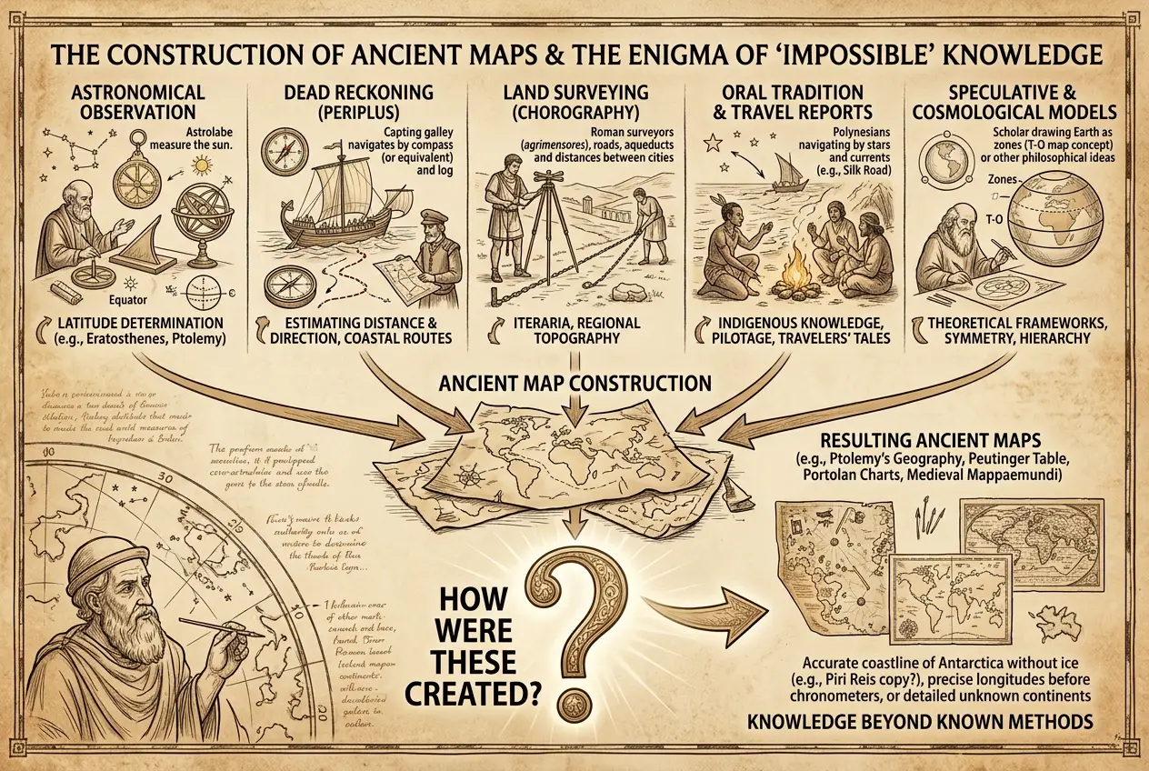
3. **A "Lost Art" of Cartography:** Perhaps certain ancient cultures developed highly sophisticated observational or even theoretical methods of mapping that were subsequently lost. This doesn't necessarily mean advanced technology in our sense, but a profound understanding of surveying, astronomy, and perhaps even early geological intuition that allowed for remarkably accurate depictions over vast areas or even long periods. The ancient world was capable of incredible feats of observation, as shown by various "ancient alignments" to celestial bodies ([Ancient Alignments: Did Structures Track the Cosmos?](blogs/ancient-alignments-did-structures-track-the-cosmos-1119)).
4. **Misinterpretation of Sources:** It's possible that cartographers like Finaeus were drawing from much older source maps that, through a chain of copies and translations, became distorted. The original accuracy might have been diluted, but key geological features persisted.
**The Oronteus Finaeus Map: A Deep Dive**
Let's zoom in on the Oronteus Finaeus map, arguably one of the most provocative pieces of evidence. Published in 1531, it showed a massive landmass at the bottom of the world, identified as "Terra Australis Incognita" (the unknown southern land). What makes it remarkable is its depiction of Antarctica with mountains, rivers, and a coastline free of ice. Modern seismic surveys conducted in the 20th century, particularly under the Antarctic ice sheet, have revealed mountain ranges and topographical features that bear a striking resemblance to those on Finaeus's map.
How could Finaeus, using 16th-century tools, have mapped a continent that wouldn't be 'officially' sighted until the 19th century, let alone depicted it in a geologically ancient state? One hypothesis is that Finaeus copied from older maps that were themselves derived from even more ancient sources. These sources might date back to a period when parts of Antarctica were indeed ice-free, perhaps millions of years ago when Earth's climate was much warmer, or even to a time closer to the last glacial maximum when the ice sheet was significantly smaller. The idea of [Pangaea](https://en.wikipedia.org/wiki/Pangaea) provides context for how continents were once arranged differently.
The debate around these maps forces us to reconsider the linearity of scientific progress. Did our ancestors possess a different kind of knowledge, perhaps observational or even intuitive, that we have long forgotten or dismissed? The implications are profound, suggesting not only a lost mastery of cartography but potentially a deeper, more holistic understanding of Earth's geological processes than we credit them for.
**Conclusion: A Persistent Enigma**
While there's no definitive proof that ancient maps *predicted* continental drift in the same scientific sense we understand it today, the existence of maps like those by Finaeus and Piri Reis presents a compelling historical and scientific anomaly. They serve as tantalizing clues, urging us to remain curious and open-minded about the true extent of ancient knowledge.
The journey of understanding our world is an ongoing one, with new discoveries constantly reshaping our perception of the past and the future. These maps are a powerful reminder that history is not always a straightforward progression, and sometimes, the answers to our greatest scientific questions might be hidden in plain sight, etched onto the very maps our ancestors used to navigate their world. The question isn't just *what* they knew, but *how* they knew it, and what other secrets might still be awaiting rediscovery.
Frequently Asked Questions
Continental drift is the gradual movement of the continents across the Earth's surface over geological time. It's a key component of plate tectonics, the scientific theory explaining how Earth's major landforms are created.
The Oronteus Finaeus map (1531) and sections of the Piri Reis Map (1513) are often cited. The Finaeus map notably depicts an ice-free Antarctica with detailed topography that aligns with modern geological findings of the continent beneath its ice sheet.
The 'how' remains a mystery. Theories range from sheer coincidence or artistic license to the possibility of advanced ancient civilizations with lost knowledge, or a sophisticated but lost art of cartography passed down through generations. There's no consensus among mainstream scholars.
Yes, alternative explanations include the maps being based on highly speculative or inaccurate reports, misinterpretations of older source material, or even skillful guesswork that coincidentally matched some future geological knowledge.
No, the mainstream scientific community largely views these claims with skepticism, attributing the apparent accuracies to coincidence, misinterpretation, or artistic embellishment rather than evidence of advanced ancient geological knowledge. However, they remain a fascinating subject for historical and cartographic study.
Verified Expert
Alex Rivers
A professional researcher since age twelve, I delve into mysteries and ignite curiosity by presenting an array of compelling possibilities. I will heighten your curiosity, but by the end, you will possess profound knowledge.
Leave a Reply
Comments (0)
No approved comments yet. Be the first to share your thoughts!
 Join Us

 Alex Rivers


Leave a Reply
Comments (0)