I’ll never forget the first time I stumbled upon the story of the Piri Reis Map. It felt like uncovering a forgotten chapter in history, a secret whispered through centuries. The year was 1929, and a group of German theologians were cataloging artifacts in Istanbul’s Topkapi Palace library. Amidst a heap of discarded materials, they unearthed something extraordinary: a gazelle-skin parchment, meticulously hand-drawn, bearing the signature of a 16th-century Ottoman admiral and cartographer named Piri Reis. What they held in their hands wasn't just another old map; it was a cartographic anomaly, a genuine historical puzzle that continues to baffle historians, cartographers, and even conspiracy theorists to this day.
**The Map That Defies History**
At first glance, the Piri Reis Map is a beautiful, intricate depiction of the world as understood in 1513. It shows the western coast of Africa, the eastern coast of South America, and astonishingly, a southern landmass that bears a striking resemblance to the coastline of Antarctica. But here’s the kicker: Antarctica wasn’t officially sighted until 1820, and its true coastline, free of its ice cap, wasn't mapped until seismic surveys in the 20th century. So, how could a map from 1513 depict a continent centuries before its discovery and in a state that wouldn't be visible until modern geological techniques? This is the central enigma that makes the Piri Reis Map a true **tech mystery** and a subject of endless fascination.
The map itself is a fragment of a larger world map, crafted by Piri Reis, whose full name was Hadji Muhiddin Piri Ibn Hadji Mehmed. A renowned admiral, navigator, and cartographer of the Ottoman Empire, Piri Reis was celebrated for his detailed nautical charts and books on navigation. His library was vast, drawing from a multitude of sources, including maps from his contemporaries, and, crucially, ancient charts. In his own notes, Piri Reis states that his map was compiled from about twenty older maps, some of which dated back to the time of Alexander the Great. This revelation alone sparked widespread speculation.
**Decoding the Southern Shoreline**
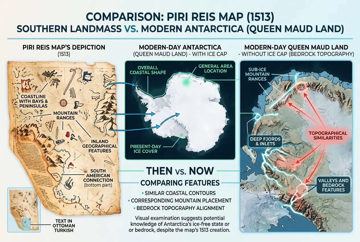
The segment of the map that draws the most attention is its southernmost portion. It depicts a continent connected to South America by a narrow land bridge, stretching eastward. This landmass shows mountains, rivers, and bays, strikingly similar to the topography of Queen Maud Land, a section of Antarctica. The problem, as I mentioned, is that this region of Antarctica has been under a mile-thick sheet of ice for thousands of years.
Imagine the implications! If this indeed is Antarctica, and if it is depicted without its ice cap, it suggests that the original source maps were created when the continent was ice-free. When was Antarctica last ice-free? Geologists tell us that the last time large parts of Antarctica were free of significant ice sheets was around 6,000 to 12,000 years ago. This pushes the timeline of advanced cartography far back into prehistory, challenging our understanding of ancient civilizations and their technological capabilities.
This is where the debate truly ignites. Is it possible that a highly advanced, long-lost civilization possessed the technology and knowledge to accurately map the Earth on a global scale, centuries or even millennia before conventional history suggests? Such a thought aligns with other **historical mysteries** like the Baghdad Battery or the Antikythera Mechanism, which hint at surprising technological sophistication in antiquity. I often find myself pondering if these isolated anomalies are just glimpses into a grander, hidden history. You can read more about other ancient tech puzzles in our blog: [The Baghdad Battery: Did Ancient Iraqis Power a Lost Civilization?](/blogs/the-baghdad-battery-did-ancient-iraqis-power-a-lost-civilization-9975)
**Theories and Explanations: Fact vs. Fiction**
Naturally, such a profound mystery generates a spectrum of theories.
**1. Conventional Explanations:**
Many historians and cartographers argue against the "ice-free Antarctica" theory. They propose several alternatives:
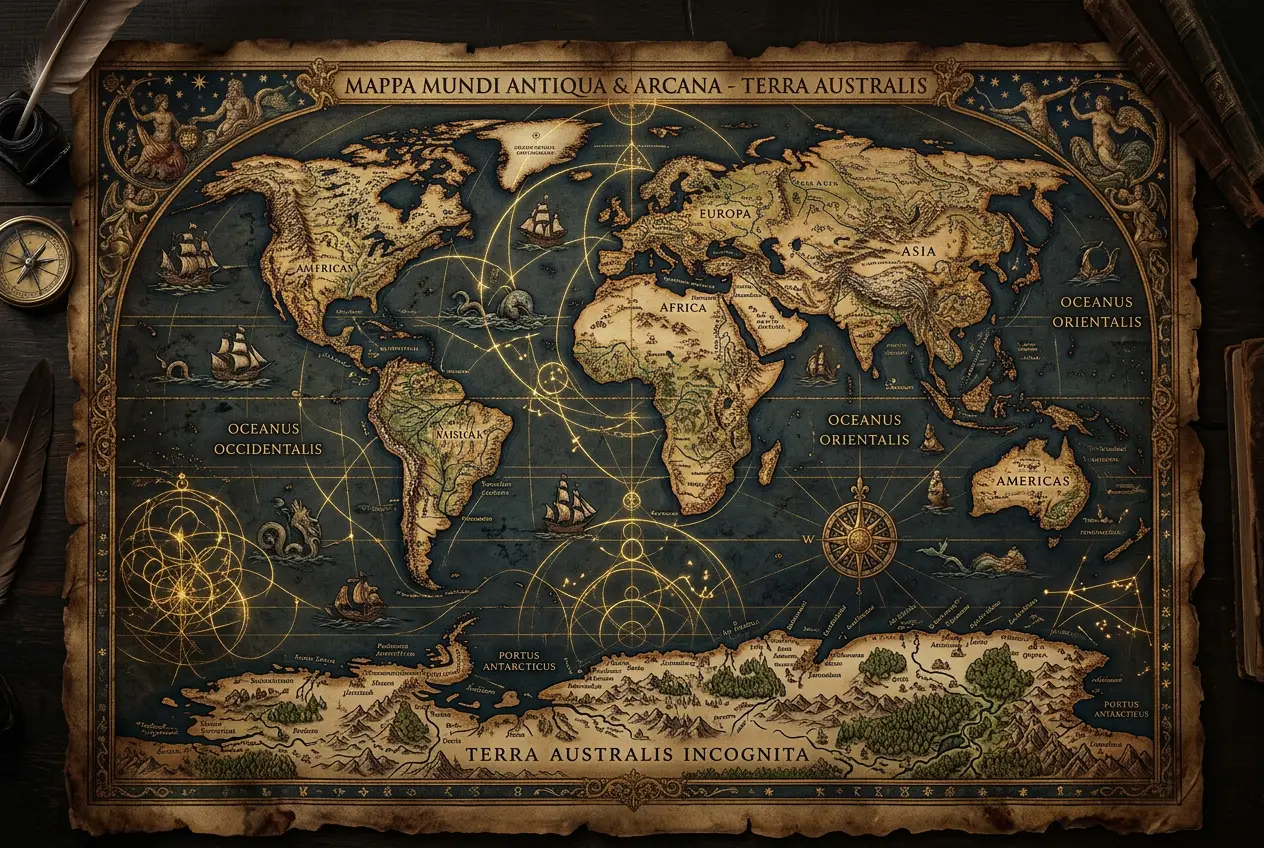
* **Coincidence or Misinterpretation:** Some suggest that the southern landmass isn't Antarctica at all, but a continuation of the South American coast, or perhaps the mythical *Terra Australis Incognita*, a hypothetical continent common in early cartography. They argue that the similarities are either coincidental or a result of misinterpretation of vague details.
* **Composite Map Errors:** Piri Reis himself admitted to using various sources. It's plausible that some of these sources were ancient, but errors could have compounded, or projections could have distorted the actual landmasses, leading to what appears to be Antarctica.
* **Geographical Speculation:** Early maps often included speculative landmasses to balance the northern hemisphere. The southern continent might simply be a cartographer's educated guess based on the prevailing geographical theories of the time.
**2. The Advanced Ancient Civilization Hypothesis:**
This is where the Piri Reis Map gets truly exciting. Proponents of this theory, most notably Professor Charles Hapgood, whose work was even endorsed by Albert Einstein, argue that the map's accuracy is too striking to be dismissed as coincidence. Hapgood, in his book *Maps of the Ancient Sea Kings*, proposed that the map originated from incredibly sophisticated source maps created by an unknown, advanced civilization. This civilization, possessing advanced navigation and cartographic techniques, would have mapped the Earth during a period when parts of Antarctica were indeed ice-free.
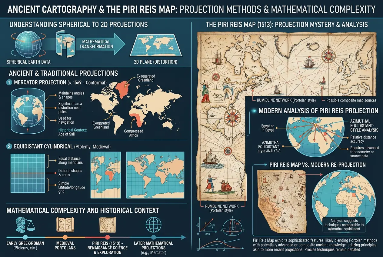
Consider the level of accuracy needed for such a map. Piri Reis's map uses a projection that, according to some analyses, is remarkably accurate in depicting latitudes and longitudes, especially for the Caribbean and South America. This level of precision was extraordinary for 1513, requiring knowledge of spherical trigonometry and potentially even accurate chronometers for longitude calculations, technologies generally attributed to much later periods. How could ancient mariners achieve this? Did they have technologies we've lost, or simply a profound understanding of the Earth and its celestial navigation? It makes me wonder about other forms of lost or hidden knowledge, much like the debate surrounding figures like Nikola Tesla and his unfulfilled promises. We explored this in our blog: [Did Tesla Really Hide Free Energy From The World?](/blogs/did-tesla-really-hide-free-energy-from-the-world-5534)
**The Role of Portolan Charts and Ancient Navigation**
The Piri Reis Map is essentially a portolan chart, a type of navigational map developed in the Middle Ages, characterized by rhumb lines (lines radiating from compass roses) used to plot courses. While portolan charts were known for their practical accuracy in coastal navigation, the Piri Reis Map exhibits a global scope and an implied understanding of the Earth's spherical nature that pushes the boundaries of typical 16th-century cartography.
The idea of ancient civilizations having an advanced understanding of the globe isn't entirely new. Ancient Greeks like Eratosthenes had remarkably accurate calculations of the Earth's circumference. However, mapping an entire continent like Antarctica, ice-free, would require not just mathematical prowess but extensive exploration and surveying over vast, remote areas. Where did this data come from? Could it be a testament to the incredible perseverance and ingenuity of early explorers, perhaps sailing the world in ways we've yet to fully appreciate? The notion of humanity possessing knowledge far beyond what we typically assume for ancient times is a recurring theme in **science explained** and **curious phenomena**, making us question the very fabric of our understanding, much like the "simulation hypothesis" itself. For more on questioning reality, check out: [Could Our Reality Be a Simulation? Decoding the Matrix Hypothesis](/blogs/could-our-reality-be-a-simulation-decoding-the-matrix-hypothesis-4299)
**The Enduring Mystery**
Despite decades of analysis, the Piri Reis Map continues to defy easy explanation. Carbon dating confirms the parchment's age to the early 16th century, and Piri Reis's authorship is undisputed. The mystery lies purely in its content. The map is not a hoax; it is a genuine artifact that challenges our historical timeline of global exploration and cartographic development.
While mainstream historical accounts remain cautious, emphasizing the lack of definitive proof for an ice-free Antarctica depiction, the map's anomalies compel us to consider possibilities beyond the conventional. It forces us to ask: What if our understanding of ancient history is incomplete? What knowledge, what technologies, what great voyages have been lost to the sands of time, waiting to be rediscovered in fragments like the Piri Reis Map?
Whether it's a testament to extraordinary ancient explorers who sailed to the ends of the Earth, a composite of maps from long-lost advanced civilizations, or merely a fascinating cartographic anomaly whose true nature we still misunderstand, the Piri Reis Map remains a compelling testament to the human desire to map, explore, and comprehend our world. Its secrets continue to beckon us, reminding me that there are always new frontiers, even in the past, waiting for our curiosity to unlock them.
**External Sources:**
* Piri Reis Map on Wikipedia: [https://en.wikipedia.org/wiki/Piri_Reis_map](https://en.wikipedia.org/wiki/Piri_Reis_map)
* Charles Hapgood's Theories: [https://en.wikipedia.org/wiki/Charles_Hapgood](https://en.wikipedia.org/wiki/Charles_Hapgood)
* History of Cartography: [https://en.wikipedia.org/wiki/History_of_cartography](https://en.wikipedia.org/wiki/History_of_cartography)
* Queen Maud Land: [https://en.wikipedia.org/wiki/Queen_Maud_Land](https://en.wikipedia.org/wiki/Queen_Maud_Land)
Verified Expert
Alex Rivers
A professional researcher since age twelve, I delve into mysteries and ignite curiosity by presenting an array of compelling possibilities. I will heighten your curiosity, but by the end, you will possess profound knowledge.
Leave a Reply
Comments (0)
No approved comments yet. Be the first to share your thoughts!
 Join Us

 Unknown Author


Leave a Reply
Comments (0)